Thinking of Pink Floyd on Vanderwhacker
pictures here
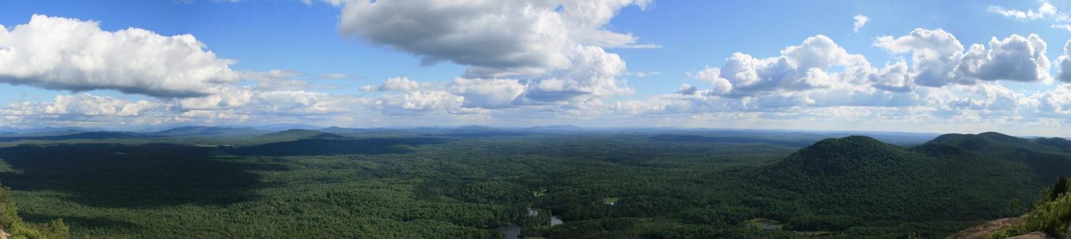
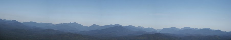
“Look mommy, there’s no clouds in the sky” was the thought that popped in my head as I stood on the summit of Vanderwhacker looking across to the high peaks. Not quite the exact wording from Floyd, but appropiate for that day.
I wasn’t going to be able to go hiking on the weekend, since I’d be in Buffalo for the Bills home opener against the Kansas City Chiefs, but still wanted to get another fire tower done. I’m down to five left, three in the Adirondacks, two in the Catskills. Hurricane was out since I’m supposed to lead a group hike in a week or two when the weather gets nice. The Catskills are out unless I can do two in one day. That left Vanderwhacker and Pillsbury. Since I wanted to take my Dad, I started looking at what other sights were in the area, and settled on Vanderwhacker with all the Teddy Roosevelt history in the area.
We left Pulaski a little after 7am, getting to the area just before 10:30am. Before we hit the turn off we stopped at the sign post by Aiden Lair, where TR stopped to switch horses on his way to catch the train to Buffalo. (Side note, the building by the sign was not there when TR was, the original Aiden Lair was across the street from the sign.)
We travelled a little further down the road and made the left turn onto the dirt road leading back to the trailhead. The road itself, for having a high clearance vehicle (Ford Ranger 2WD) was in good shape. The campsites back there were in better shape than some I’ve seen in other remote/wilderness campgrounds. Only one was taken by a trailer, probably by a hunter from the looks of it. We eventually reached the turnoff to the parking area. As noted in other reports, low clearance vehicles might make it up there. But if you’re worried, parking along the road will only add a few hundred feet to your hike.
While loading up we noticed there is an outhouse off to the right of the trailhead register, if you need it. The first part was a nice walk through the woods. The trail was in good shape, no real mud with the lack of rain we had. One bridge though had been lifted by a tree that came out of the ground. We covered the first mile plus in just over half an hour. There’s some pressure treated lumber there, so it looks like they may be doing some work on the observers cabin soon. I’ve seen other trip reports that call the collapsed building a shed. From what research I’ve done, I believe it is actually the pre-1950 observer cabin.
After a short break we started up the fun part of the hike, gaining about 1300 feet in a little over a mile to the summit. The trail was in good shape, nothing real notable in terms of trouble spots. We did find three resting rocks on the way, only got pictures of two. And the stairway at the switchback was cool to see in person.
About 50 minutes after leaving the cabin I caught the first sight of the tower. I then gave a quick history lesson to my Dad about the three eyebolts and how Colvin did his surveying back in the late 1800’s and pointed out the summit marker there from 1880. We then headed up the 35′ fire tower to check out the views. Perfect viewing in all directions that day, the high peaks were a little hazy but easy to pick out.
Headed back down and found a ledge off to the side facing the high peaks to sit and eat lunch. The dragon flies were out and huge. Also saw a hawk circling a few times, but of course once I had my camera ready, he never appeared again. Once done eating we headed back down. Only saw one other person on the trail, but it turns out he works for the DEC. He was doing a survey of the bridges along the trail to see how many needed repairing or replacing.
Left the Parking area and headed back out to the main road, taking a left and heading up to Tahawus so Dad could see the blast furnance and Adirondac. I’d been there back in April so I didn’t bother with any pictures this time. It appears though that there is a new parking lot and trail leading to the blast furnance that wasn’t there earlier this year.
We headed to the end of the road and Upper Works parking lot. For a Thursday in September, I was amazed at how packed it was, 14 vehicles, and 20 people signed in on the register, some day trippers, some backpackers. We walked down the road and checked out some of the collapsed buildings, but the main destination was the Tahawus Club building. I hope they can get the restoration done soon.
Overall, a long day, but good day of hiking and history.
Specs
- Distance – 5.13 miles
- Elevation – 1686 feet
- Time – 3 hours 59 minutes